Hi! If you’re new here, this is Map Nerd. We explore amazing places and cool things on maps, usually with a video story + quick digestible info. If you enjoy it, subscribe and you can explore with us!
The latest news explained with good maps and the latest good maps that have hit the news. But mostly quick links to fun maps that you can procrastinate with 😊…
➭ Human Feet Routinely Wash Ashore in the Pacific Northwest. Yes. This one is a tad gruesome and a lot fascinating. The below map was produced by the coroner of British Columbia (Canada) because I guess we all need a handy guide to where severed feet are found?
It turns out that the Salish Sea around the Vancouver area is one of the foremost receptacles for disembodied human feet. Apparently there’s nothing nefarious about it; many corpses end up in the sea around metropolitan areas (NYC even has a yearly ritual of finding floating bodies during the spring thaw).
If you’re curious (because I know you are), here’s the basics of what makes Vancouver a severed foot hotspot: the friction of the waves tend to disassemble limbs at their joints, and a foot wrapped neatly in a buoyant pair of Nikes is the perfect vessel to surf the currents. The particular currents in the Salish Sea push “floaters,” as they’re called, onto the shores around Vancouver. The below map covers a bunch, but, amazingly, it’s not even updated with the most recent findings… 😳
The location of feet that have washed ashore in and around the Vancouver, BC area (from the British Columbia Corners Service).
Christie’s auction house was selling items from the estate of Ann & Gordon Getty which included a 16th century map worth an estimated $100,000-$150,000. However, when the map dealer took a closer look, he noticed that Granada in Spain had a curious flag that didn’t match the rest of Spain. That was his smoking gun: Granada was the last holdout of the Moorish kingdom in Spain, which surrendered to Spain in 1492, which is well before the 16th century date that Christie’s assumed.
The story ends with the map dealer purchasing the so-called “16th century map” for $239,000, and then scientifically authenticating that it is actually from circa 1360! Not only is that far earlier than anyone thought, but it also makes it one of the earliest known maps of this type to exist (called a Portolan Chart - read the article to find out why they are so special).
The map dealer updated his price tag: it is now on sale for a cool $7.5 Million… 🤯
A 14th century Portolan Chart that was discovered recently at an estate sale is asking for $7.5 Million.
➭ 42 New World Heritage Sites. The UNESCO World Heritage Convention had its annual meeting in Riyadh this September where they inscribed 42 new places onto the World Heritage List.
There are currently 1,199 World Heritage Sites around the world, each being recognized for “outstanding universal value” by an international panel made up representatives from 21 countries. Inscription onto the list significantly impacts the preservation of each place for future generations.
New sites added this year include: memorials to the 1994 Rwandan Genocide, the island volcanoes of Martinique, and a Viking ring fortress in Denmark…
New Inscribed World Heritage Sites (clockwise from top left): Gaya Tumuli, South Korea / Cold Winter Deserts of Turan, Central Asia / Guimarães & Couros, Portugal / Hyrcanian Forests, Iran / Sacred Ensembles of Hoysalas, India / Ha Long Bay, Vietnam (from UNESCO)
➭ How Many Californians Are Actually Moving To Texas?According to The LA Times, 100,000 Californians moved to Texas in 2022. But 40,000 Texans went the opposite way too. So Texas netted about 60,000 in the exchange.
It’s true that Texas topped the list for Californians moving out of state, but 718,000 Californians went to other states too (there was a total gross migration of 818,000 in 2022).
New Jersey had the most net moves to California with 6,600, because, well, it’s New Jersey 😉…
2022 Saw 818K Californians move to other states, and 476K from other states move to California (from LA Times).
➭ Google Maps Changed Colors and People Are Mad. Not sure if you’ve noticed, but Google Maps changed the colors of its map. They rolled out an update in September, which dramatically alters the colors of map tiles.
Unsurprisingly, Google fans went nuts; most are unhappy about the change, accusing it of being “too cold", the hues “too close together,” and looking too similar to Apple Maps. I don’t mind it though. What do you think?… 🤔
Google Maps updated its color scheme towards a colder look that’s closer to Apple Maps with roads in gray, water in teal, and parks in mint.
Here I share one beautiful slash fascinating map plus one absolutely terrible map. Hopefully you’ll be mesmerized by something interesting and then laugh at something absurd.
➭ 😍 Good Map: A Burnt Ski Resort Revives Itself With a New Map.Lake Tahoe ski resort Sierra-at-Tahoe was decimated by the 2021 Caldor Fire which burned 221,000 acres that included 80% of the resort. It was forced to close thereafter and removed some 14,000 trees from its trails. This year, Sierra-at-Tahoe is set to re-open, though it looks like a completely different place. The resort had to re-do its map to account for all the changes to the landscape, and the results are striking. Both maps a beautiful in distinctive ways, and the difference between them really concretizes the effects of climate change in real time…
Trail maps of Sierra-at-Tahoe ski resort, before a devastating 2021 wildfire (left), and after (right)
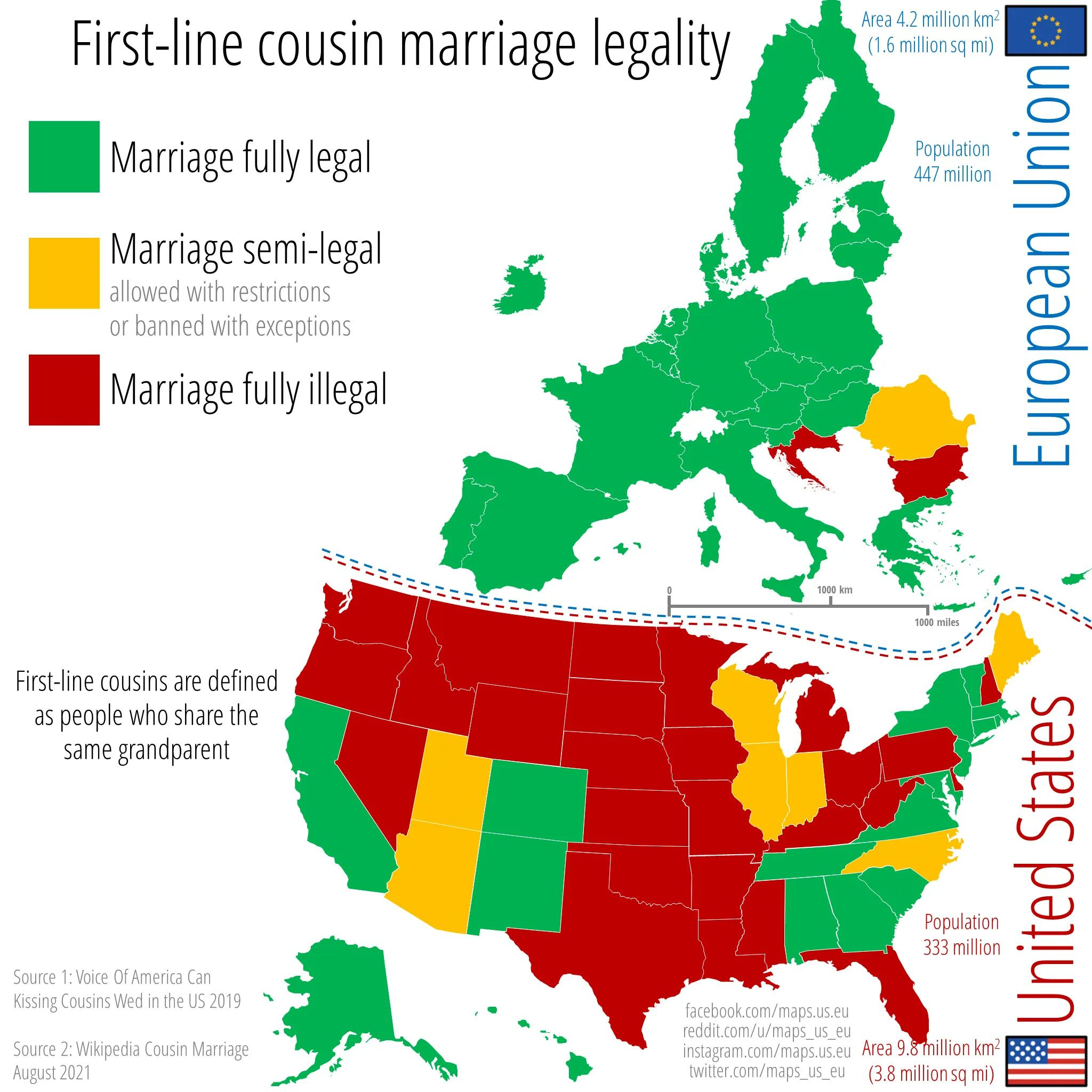
➭ 🙄 Bad Map: Where Can You Marry Your First Cousin? Good question (is it?). The below map from maps.us.eu shows you where you’d need to go if you want to tie the knot with your cousin. Surprisingly, 18 states and almost all of Europe allow first-cousin marriages without restrictions!…
This is a calibration target for a satellite to focus its camera.
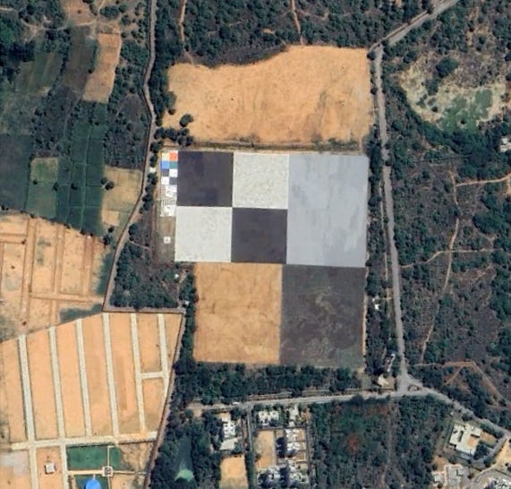
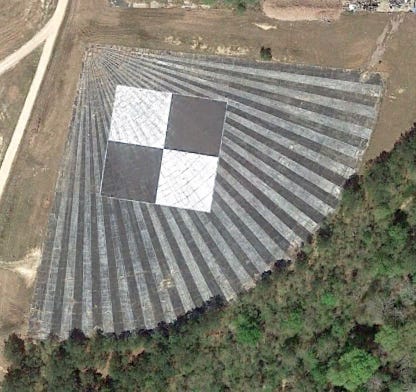
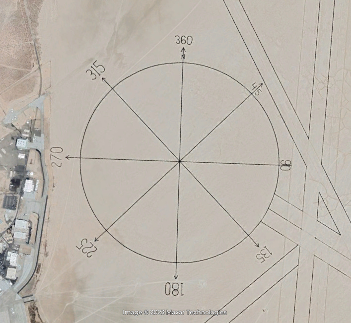
They’re all over the world. It’s very possible you live near one of them and never knew it. Like thousands of massive barcodes on Earth’s surface, they’re shaped like squares, circles, grids, and strange triangles that look like something out of a geometry test.
They’re used to like giant eye charts for aerial surveillance - to focus and orient the lenses on satellites, weather balloons, spy planes and I’m sure plenty other things we’re not supposed to know about hovering over our heads.
The oldest one we know about is this 4000ft compass drawn in a lakebed at Edwards Air Force Base in California in the 1930s:
Lots popped up in the 50s and 60s, which you can visit now, including these crosses in Arizona which cover 16 square miles:
They’ve been replaced by much more sophisticated versions, only a portion of which we’re aware of because, well, we can see them. Assume they can see you too. 👀
Find Them Yourself 🕵🏻♂️
Here are the locations of calibration targets from the video so you can see them for yourself. Maybe it’ll help you focus (get it?)…
👀 More Interesting Ground Calibration Targets Around The World…
There’s lots more where those came from. Here’s the best of the rest IMO…
Edwards Air Force Base has markers etched into the dry lakebed that stretch for miles, one resembling a giant ruler (top image: top left).
Two very neat bullseyes with seemingly perfect circles are manicured into the desert landscape of Cuddleback Lake, California (top middle).
Vehicles and structures are placed in curious concentric rings in China - I’ve heard that this is possibly a test of what objects can deceive, or be hidden from, radar (top right).
China has many more curious lines in the land, including this seemingly randomized rectangle that measures more than a mile across (bottom left).
The Casa Grande Test Range forms a 16 X 16 mile grid in southern Arizona, with a 60-foot concrete cross poured on the ground at each mile. The site was decommissioned in the 1970s, but more than 150 crosses still exist (bottom middle).
Lastly, Eglin Air Force Base is another American hotbed for targets, including a random line pattern, which appears to be attempting to replicate an overhead view of a small village (bottom right).
📁 For those of you Google Earth-inclined, here’s a KML file of all the above locations and more for your viewing/spying pleasure… (you can download it here). I made a map too (below), because, well, I like maps…


.")