

Is Africa Splitting Apart? 🧐
Plus Grabens, Slips, Dips, & Horsts (🧐Map Facts)

Hi! If you’re new here, this is Map Nerd. We explore amazing places and cool things on the world map, usually with a video story + quick digestible info. If you enjoy it, subscribe and you can explore with us!
In This Post:
This Week’s Video: Is Africa Splitting Apart?
Other Major Rifts You Didn’t Know You Knew
Grabens, Slips, Dips, and Horsts (they’re not characters from a Dr. Seuss book)
Is Africa Splitting Apart?
Great Rift Valley & The Silfra Fissure
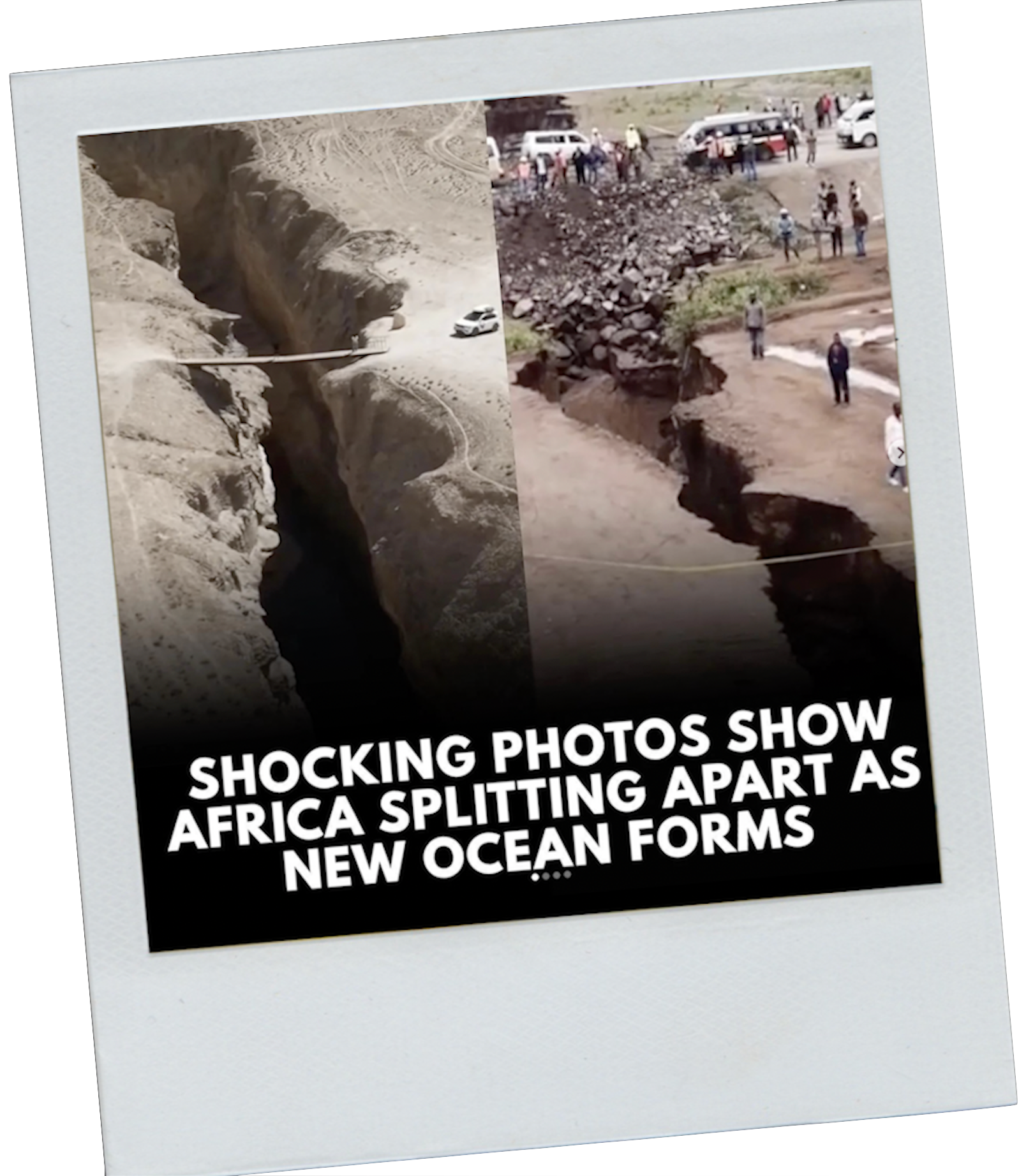
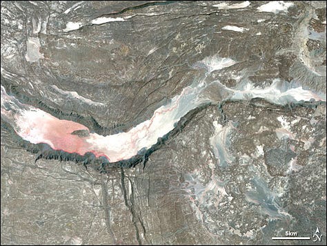
I got hit with this image a few days ago and some of you sent it to me too. It’s apparently proof that Africa is splitting.
Not so fast.
That is NOT proof that Africa is splitting.
THAT is erosion due to heavy rains in Kenya in 2018. But that doesn’t make it less scary, and the basic conditions which allowed this to happen are definitely tied to millennia of tectonic plates shifting below the ground.
That shifting WILL eventually split Africa, though it might take about 5-10 million years.


The ground below us sits on these giant tectonic plates that are slowly but constantly moving beneath our feet. (I’m not a geologist so that’s the deepest I can go with that).
We don’t usually notice it unless there’s a big event like an earthquake, but over long periods of time those movements do create rifts that we can see (and jump into in some cases).
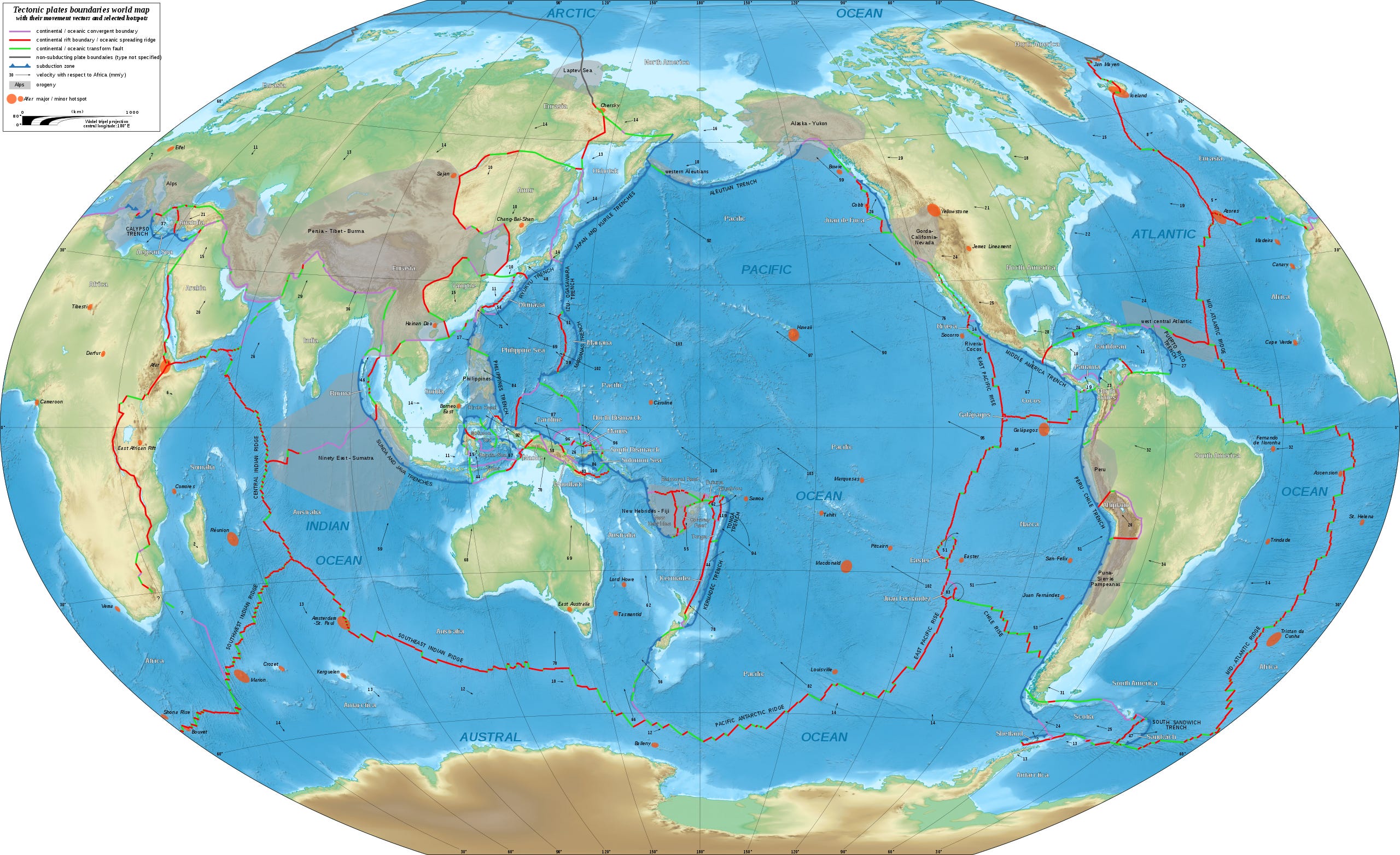

There are rifts all over the world. They’re pretty incredible. If you zoom out, you can make out the outlines of the different plates – kind of like seams that stitch together the globe.


One of the coolest is the Silfra Fissure in Iceland, which is a real live current split between two tectonic plates. It’s also the only one I know of that you can dive into. Yeah, you can swim between the plates of the earth here. I’m just waiting for dinosaurs to pop out.


Other Major Rifts You Didn’t Know You Knew
There are rifts all over the world. Many of the largest are deep below the oceans (which makes sense since the continents are the current result of a long, long, and continuing, process of splitting). But, many of them you can see. You’ve probably visited one but you didn’t know you were visiting one. Now you will know you are visiting one, and you will never be able to un-know it.
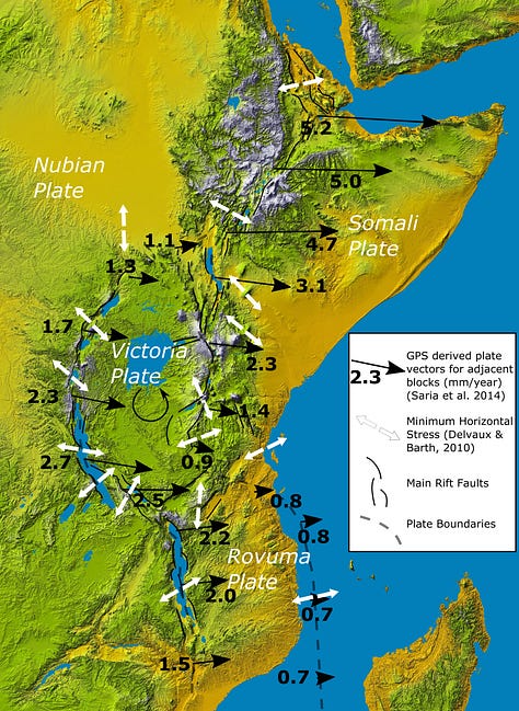
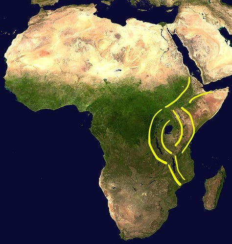
East African Rift, Africa: Running from Mozambique north through the Horn of Africa, the East African Rift is 4,000 miles long and cuts through at least 12 countries in the eastern portion of the African continent. It’s the African continental plate that is slowly, but surely, splitting into two separate plates (the “Nubian Plate” and the “Somali Plate”). Best estimates say it’s moving at a rate of about 6-7 millimeters per year, which should result in an actual physical split in about 5-10 million years. The expectation is that the whole rift will eventually fill in with ocean, making the two plates very visibly distinct. That’s already starting to happen: you can see a distinct line of large lakes that connect like a worm (or somewhat deformed snake) formed as the plates divide deeper and wider. The full length of the East African Rift is clearly visible from space, with the division showing up as a distinct line of disturbed earth; disturbed by narrow lakes, valleys, mountains, canyons, and volcanoes. Interestingly, the rift breaks into 3 parts up at its northern tip, which creates the Red Sea, the Gulf of Aden, and Arabia (see map below). That’s called a “triple point” and it’s the only triple point visible above ground.
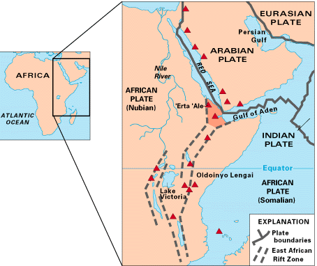
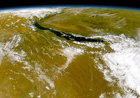
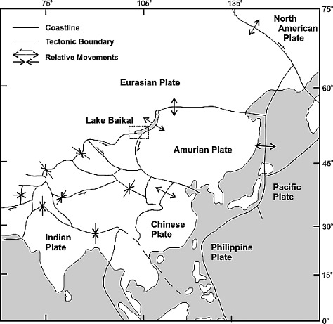
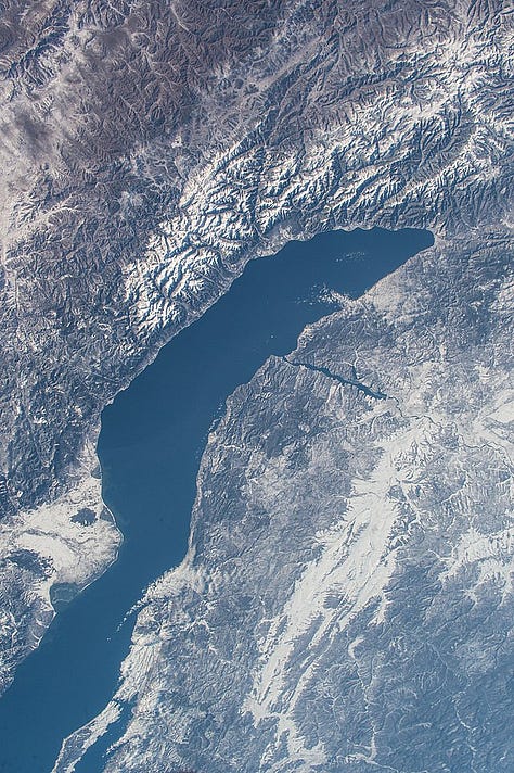
Diagrams of the East African Rift & Afar triple junction rift Baikal Rift Valley, Russia: Lake Baikal is the largest freshwater lake in the world. It’s also the deepest lake and probably the oldest. It holds more than 20% of the planet’s surface freshwater, which is more than all the US’s Great Lakes combined. And, cue drumroll, it’s one massive rift. Lake Baikal formed from splitting of the Eurasian and Amur Plates below Russia. Once you know it’s a rift/split/seperation of plates, it’s very hard to un-see!
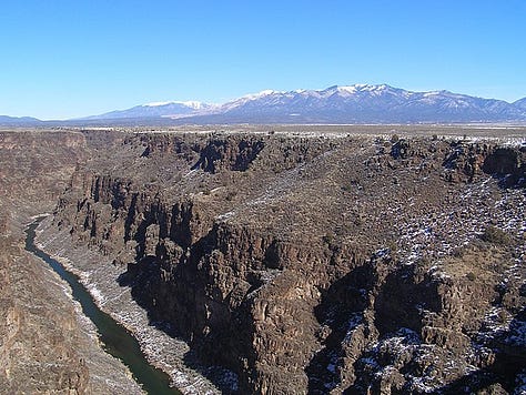
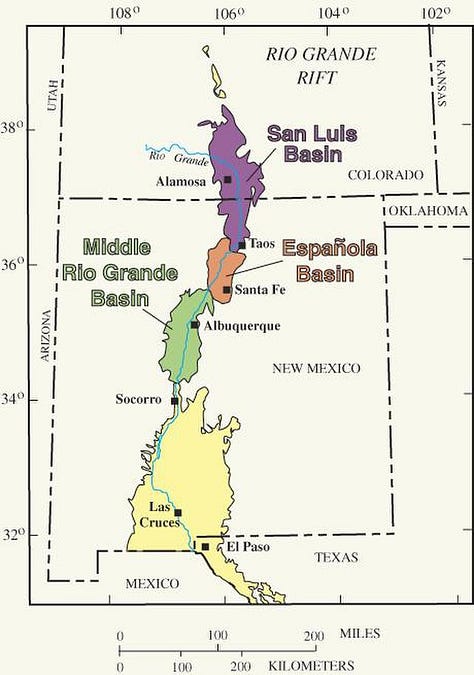
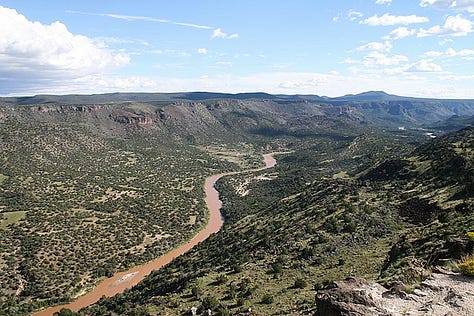
Images & Diagram of Lake Baikal and Baikal Rift Valley Rio Grande Rift, USA: For us Americans, we can get a little closer to home. The Rio Grande rift passes from Colorado through New Mexico and Texas, mostly following the Rio Grande River. The plates splitting here have formed multiple canyons, valleys, and basins that are particularly stunning. The main north-south artery of cities, highways, and people in New Mexico follows this rift. You can even see it on a road map.
Images & Diagram of The Rio Grande Rift in New Mexico


Comment below and add a rift near you! Google “rift” and see if something pops up that you know and explore a little bit!

Grabens, Slips, Dips, and Horsts
These are not characters from a Dr. Seuss book (though they should be 🤔)
When researching the world of rifts, I necessarily slipped and fell into the world of faults of all sorts. I learned just enough to know that the intricacies of plate tectonics are well above my pay grade, but the names they come up with are right in line with it 😉).
When the tectonic plates under our feet move away from each other, it typically creates a rift. But, like bumper cars on ice, the plates move in all sorts of other ways, and each of those other ways make a mark on the earth that gets its very own special, and Dr. Seussy, name.
Plates move in 3 general directions: apart (divergent boundaries, a la rifts), into each other (convergent boundaries), and side-by-side like two pieces of sand paper rubbing against each other (transform boundaries). Out of those 3 general buckets come dozens of names for more specific interactions. Here are the fun ones:
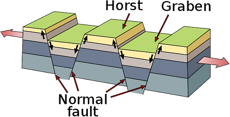
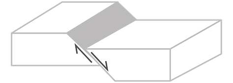
Graben: when parallel fault lines cause the block of land in between them to slip downward, it forms a narrow valley bordered by a steep slope or cliff on either side (although one side can be significantly steeper and taller than the other, in which case the graben part can be called a “half-graben”). Apparently graben is German for “dig” or “ditch.” (any German speakers want to confirm?)
Horst: to complement a graben, there’s usually a horst. That’s the elevated portion on top of the cliffs. Usually a horst stays put while the grabens continue to slowly fall downward, making the horst taller and its edges steeper as time goes on. This word also comes from German (“heap,” “nest,” “tuft”). But I’ll be damned if they don’t use it in Whoville.
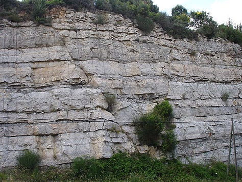
Grabens & Horsts (L to R): Afar depression, graben & horst diagram, Mourèze France Strike-Slips: a stike-slip fault describes a transform fault where the two plate boundaries move horizontally against each other. Californians and Dwayne Johnson fans will be familiar with this one: its most famous example is the San Andreas Fault in California.
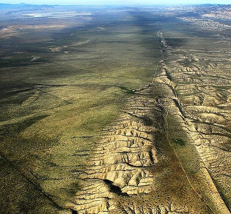
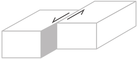
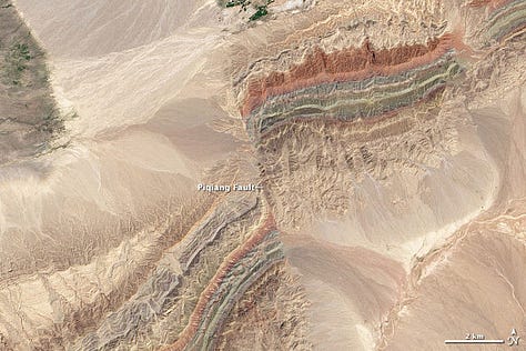
Slip-Strike Faults: San Andreas Fault California, strike-slip diagram, Piqiang Fault China Dip-Slips: in a dip-slip fault, the plates are also rubbing side-by-side, but the resulting friction is mainly vertical (vs the horizontal of the strike-slip). Dip-Slips can create graben and horsts (see how I went full circle there?)
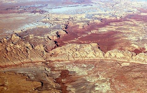
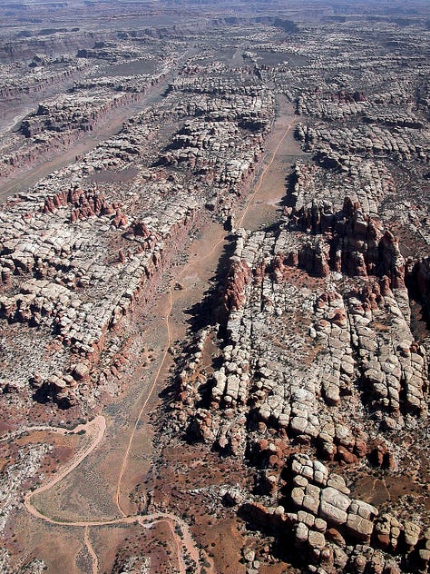
Dip-Slip Faults (L to R): San Rafael Reef Utah, dip-slip diagram, Canyonlands National Park


I knew a Horst Graben once. Nice guy. Sorry, bad joke! LOL.
Silfra Fissure looks amazing!