

The Perfect Circle Island 🗿
Also: Gift List, The US If Secessionists Won, & The World's Most Mined Country (🗿Amazing Places Series)


Hi! If you’re new here, this is Map Nerd. We explore amazing places and cool things on maps, usually with a video story + quick digestible info. If you enjoy it, subscribe and you can explore with us!
In This Issue:
Updates! Gift List, taking recommendations!
Maps On News & News On Maps: Las Vegas Sphere, Ukraine’s landmine problem, & why the Big Ten makes no sense
Good Map / Bad Map: Food according to Italy, The US if secessionists had won
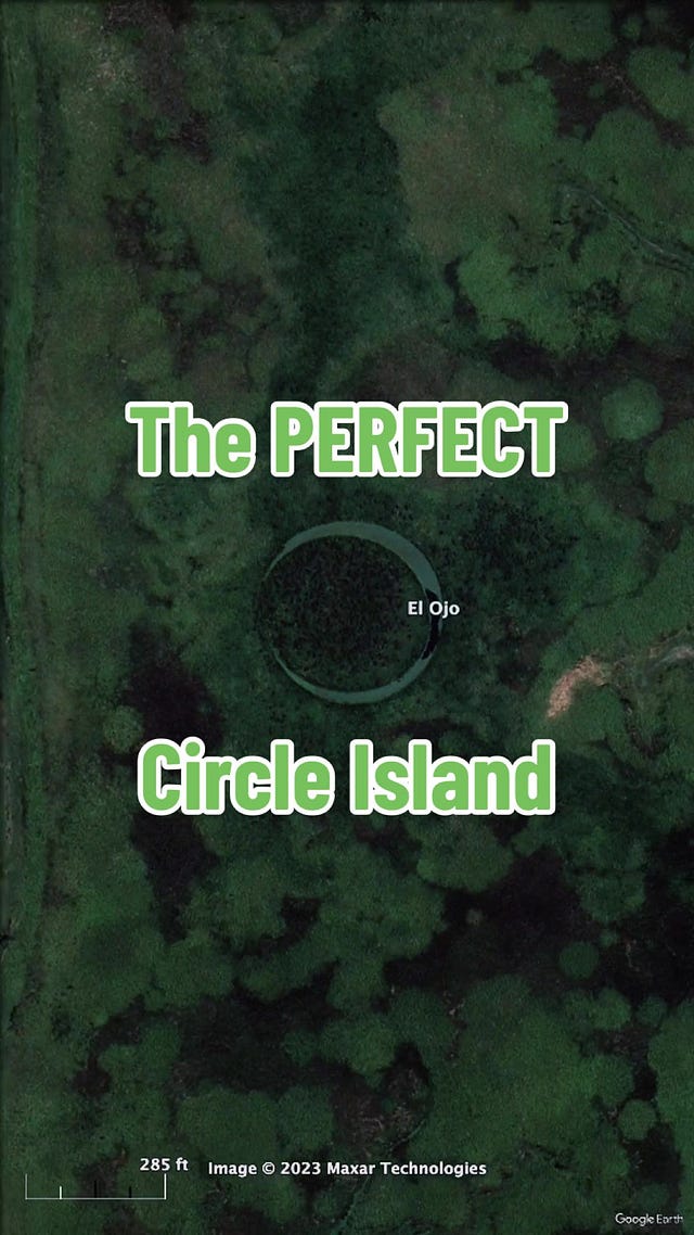
This Issue’s Main Story+Video: The Perfect Circle Island! Argentina’s El Ojo
FYI the last sections may get cut off in your inbox - click “view entire message.”
📣 Updates! 📣
🎉 A Special Welcome to the new map-curious friends that joined since the last edition. Map Nerd was featured on MSN and SiriusXM recently(!). If you heard about us there, thanks for taking the extra step and subscribing - it means a lot. 🙏
🎁 Gifts For Map Nerds: Based on popular demand (aka a few requests plus an urging by my son), I’ve opened up a Gift List with recommendations of what to get your map-loving friends for any occasion. It’s a pick of my favorite geography (and geography-related) things. For now I’ve started with books, but will soon expand to maps, globes, games, toys, tech, and fun travel things. Check it out!
📢 Also, I want to hear from you WHAT YOU RECOMMEND??? If you have a suggestion for a great item to get for geography-loving friends and family, let me know in the form HERE. As more respond, I'll keep a running list for all of us to have and to hold dear :)

🗺️ Maps On News & News On Maps 🗺️
The latest news explained with good maps and the latest good maps that have hit the news. But mostly quick links to fun maps that you can procrastinate with 😊…
Sphere Las Vegas: If you haven’t heard or seen yet, allow me to introduce you to Las Vegas’ newest entertainment spectacle: The Sphere. At 366 feet tall and encompassing a massive 875,000 square feet, It’s the world’s largest spherical building and the world’s largest LED wall. The Sphere promises to host ground-breaking events, shows, and concerts: there’s a 250-foot-high 16K wraparound screen behind the stage, seats with haptic response, effects that change wind & temperature & scent, and innovative sound delivery technology that can isolate audio to specific areas (so people in different seats can hear different things). The reason I’m sharing it in a map blog, you ask? It’s the perfect canvas for an eye-popping globe, and the Sphere has so far had a lot of fun with the Earth, Moon, and Mars…


Just some of the many "faces" (or should I say "eyes?") of the new Sphere Vegas Plans for a $2 Billion Disneyland in Oklahoma: Yes, you read that right. A $2 Billion theme park on the scale of Disneyland is being planned for northeast Oklahoma. Currently being called the “American Heartland Theme Park and Resort,” the just-released plans show it'll eventually cover 125 acres (Disneyland, without California Adventure, is roughly 100 acres). It will feature rides and attractions based on “American themes,” with plans for 6 “lands:” Great Plains, Bayou Bay, Big Timber Falls, Stony Point Harbor, Liberty Village, and Electropolis. Electroplis sounds like it was thrown in there at the end to get some metropolitan representation.
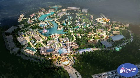
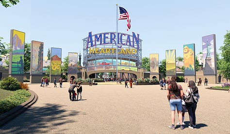
Renderings of proposed American Heartland Theme Park & Resort near Grand Lake, Oklahoma (from americanheartlandthemepark.com) Ukraine is now the most mined country on Earth: The Washington Post estimates that land mines now cover a Florida-sized portion of Ukraine, which makes it the most mined country in the world. 30% of Ukraine, or 67,000 square miles, have been exposed to mines. “The sheer quantity of ordnance in Ukraine is just unprecedented in the last 30 years. There’s nothing like it…”

This is how big the mine problem is in Ukraine: mines cover about 30% of the country, equivalent to the size of Florida (from Washington Post) 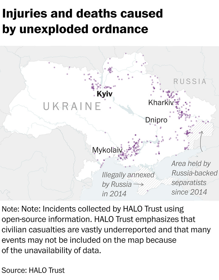

LEFT: Map of recorded injuries & deaths caused by unexploded ordinance in Ukraine. RIGHT: map of recorded ordinance contamination in Ukraine (both maps' data from HALO Trust via The Washington Post) The UK’s World Heritage Map: UNESCO UK released a very pretty illustrated map of significant UNESCO sites across Great Britain & Northern Ireland. What I like about this map, which is also interactive in an online version, is the choice to uniquely stylize what could have been a copy+paste from Google Maps with pins.

Illiustrated map of UNESCO Sites in the UK. Pretty! (from unesco.org.uk) What if The US Actually Took Rail Seriously?: As part of the US’ big push to upgrade infrastructure, the Federal Railroad Administration (yes, that’s apparently a government agency) developed a conceptual plan for what future long distance train travel could look like in the USA, using many existing rail lines that are out of service or underused…

Is this the future of Amtrak? The FRA’s “conceptual” map shows what an expanded US train network could look like, utilizing many existing rail lines The Big Ten Makes Absolutely No Sense: for sports fans, here’s a nice map illustrating what happens when a regional football conference forgets about the regional part, a la the recent expansion of the formerly midwest, formerly ten, BIG 10 Conference, which will now be 18 teams from coast to coast. As one user tweeted/x’d: “logistics have left the chat.”

Map of the Future Big 10 Conference (via X: @FieldYates) The World’s Coastal Risk: This fantastic interactive map from Climate Central meshed giant datasets to make a map of ALL the areas around the world that could be underwater as temperatures and sea levels rise. You can scale up/down things like temperature, ocean rise, and rate of Antarctica’s ice melt to see how any coastal community may be affected…

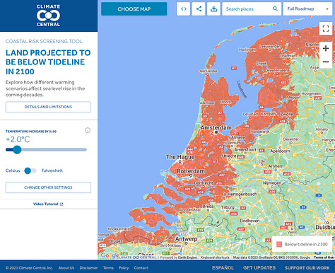

Just a few of the areas projected to be underwater by year 2100 (from climatecentral.org)


😍 Good Map / Bad Map 🙄
Here I share one beautiful slash fascinating map plus one absolutely terrible map. Hopefully you’ll be mesmerized by something interesting and then laugh at something absurd.
Bad Map🙄: ok, to be fair, I don’t believe this is actually a “bad map.” In some respects, it’s kind of awesome actually. Different Maps serve different purposes, and if you consider enjoyment and a quick laugh one of those purposes, then this map has done its job. Otherwise, it’s not accurate or useful. But I don’t think that’s the point…
")
The Culinary Map of Europe According To Italy seems to indicate Italians have a distaste for other nations’ foods. Shocker. (from www.atlasofprejudice.com) Good map😍: My colleague Frank Jacobs (one of the godfathers of the map nerd genre if that were actually a thing) wrote a great article about this 1864 map that boldly warns what the USA could become should the Civil War end in separate nations. It’s beautifully illustrated, and is a great example of the power of maps to convey a message, particularly political sentiment.

This vintage map, published in 1864, reflects anti-secession sentiment by taking secession to an extreme conclusion. Which country would you be in had it all gone south (no pun intended)? (from Boston Rare Maps via Atlas Obscura)
")


This Issue’s Story + Video:
🏝️ The Perfect Circle Island 🏝️
Watch The Video Below! or on YouTube here
 Tiktok failed to load.
Enable 3rd party cookies or use another browser
In Argentina, there’s a very strange very circular island called El Ojo, The Eye. It’s a near perfect circle of land inside a near perfect circle of water, and that’s just too near perfect for many to believe its natural.
But it is. We’re pretty sure.
El Ojo is outside of Buenos Aires in the Paraná Delta, which is where the Paraná River meets the Uruguay River and heads to the Atlantic Ocean, making a giant mash of islands and rivers.
Some say its aliens, a secret experiment, or teenagers playing games.
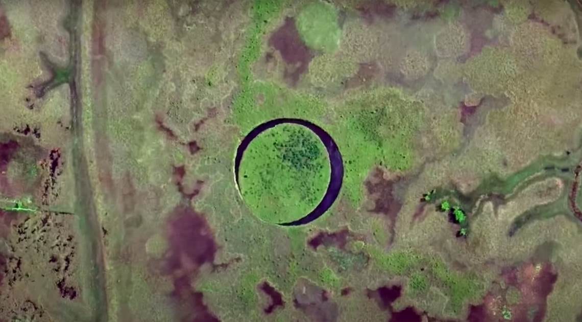
But it just takes a little zooming out to notice that El Ojo is not unique. There are circle islands all around the Paraná River.


So what’s going on here?
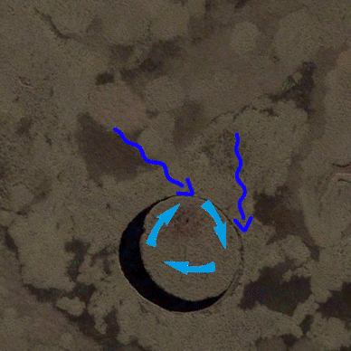
These cool circles are products of rotational shear: a unique phenomenon that can happen when conditions are just right, like here near the Paraná River. Patches of swamp break off and currents slowly spin it around its own axis, grinding its edges equally as it turns to form a neat circle. It can happen with ice too, but ice discs, or ice crepes as Canadians call them, only get sighted every couple of years.
It can happen with ice too, but ice discs, or ice crepes as Canadians call them, only get sighted every couple of years.

All this said, El Ojo hasn’t been studied enough to determine conclusively that it’s caused by rotational shear. So… there is still a possibility it’s aliens. 👽🤷♂️


❄️ More on Circle Islands, Ice Discs, & Barbie Again ❄️
▶︎ If you’re curious for more, Science Channel went to El Ojo on their show “What On Earth?”…
▶︎ Also, a nice quick primer on ice discs with a rare occurrence from 2019 in Maine…
▶︎ And lastly, but certainly not least, I had previously posted about the Barbie map fiasco, but I found it fascinating so I did a quick video on it for socials too, in case you’re interested (who are we kidding, i KNOW you’re interested)…
